


About this Webcam
Safe pathways for wildlife and people
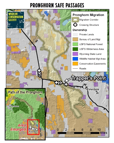
The webcam was originally installed as part of a project by the Wildlife Conservation Society to bring attention to the migration pathway many pronghorn take to reach summer range in Grand Teton National Park. Each year, approximately 300-400 pronghorn from the larger herd make the trek all the way from the Red Desert to the Park and back again, a pathway that has been named the Path of the Pronghorn. The wildlife overpass bridge at Trapper's Point over U.S. 191 is part of a larger project done by the Wyoming Department of Transportation. The Wildlife Conservation Society (WCS) helped identify intersections between pronghorn migration corridors and US 191 where under and overpasses with fencing could guide pronghorn safely across the road and reduce wildlife- vehicle collisions between pronghorn and motorists. In 2010, the Wyoming Department of Transportation (WYDOT) used this information, along with complimentary data from Wyoming Game and Fish Department and other researchers, to invest $9.7 million along US 191 to install fencing and crossing structures to protect both wildlife and highway travelers. In the fall of 2012, 8 wildlife crossing structures and 23 kilometers of fencing were completed along a 12-mile stretch of highway. A second wildlife overpass bridge is located about five miles north of the Daniel Junction. Wildlife biologists have cameras at some of these locations. WCS is currently studying the effects of the structures and the adaptations of the pronghorn at Trapper’s Point in order to utilize lessons learned in other crucial wildlife road crossing locations around the world.
Studying the Path of the Pronghorn
Wildlife Conservation Society (WCS) researchers have been studying the Path of the Pronghorn since 2003. In 2008 the Path of the Pronghorn became the first federally designated migration corridor. Years of field research by WCS were pivotal in the effort to designate the first and only federal migration corridor in the U.S. Further, this research helped inform the Wyoming Department of Transportation of the optimal locations for installing wildlife crossings and fencing to protect the migration and drivers. The live web camera installed on the overpass provides the public with a real-time look at activity on the overpass and gives researchers additional information about the timing and numbers of wildlife movement patterns.Duck Creek Path of the Pronghorn
Interpretive Pullout
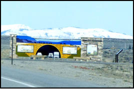
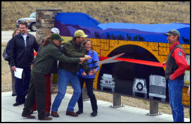
Few people have opportunities to see and appreciate the value of seasonal wildlife migrations. The Trappers Point Wildlife Overpass webcam provides a unique opportunity for the public to directly observe pronghorn and other species moving across the overpass. WCS has partnered with many other organizations to design and install an informative interpretive site along US 191 approximately a mile east of the overpass that provides information about the pronghorn migration and the infrastructure investments that have been made to conserve these migratory movements. The ribbon cutting for this interpretive site was held on Wednesday, April 13, 2016. Pronghorn Migration Interpretive Site (Pinedale Online, April 13, 2016, 14 photos)
Path of the Pronghorn
Interpretive Pullout
The Ribbon Cutting Ceremony for the Path of the Pronghorn Wildlife Crossing Structures Interpretive Site was held on Wednesday, April 13, 2016 at 5:30PM at the Wyoming Wildlife pullout. It is located approximately one mile east of the Trapper's Point wildlife overpass bridge on U.S. 191 along Duck Creek.
Moving forward
Pinedale Online took over as managers of the Trapper's Point Wildlife Overpass webcam on April 1, 2016. We are excited to be able to help continue to make this webcam available to wildlife researchers and for public viewing. The webcam allows researchers to learn more about the seasonal movement patterns of big game wildife in the Upper Green River Valley, as well as offering people from all over the world a chance to observe these animals in real time through a live video feed. We welcome suggestions from researchers and interested persons on ways to make the camera more beneficial and to help educate the public on conservation, well-thought out land-use development to accommodate multiple uses, wildlife management challenges and opportunities, and non-disruptivel wildlife viewing practices. Wildlife Conservation Society (WCS) researchers have been studying the Path of the Pronghorn since 2003. In 2008 the Path of the Pronghorn became the first federally designated migration corridor. Years of field research by WCS were pivotal in the effort to designate the first and only federal migration corridor in the U.S. Further, this research helped inform the Wyoming Department of Transportation of the optimal locations for installing wildlife crossings and fencing to protect the migration and drivers. The live web camera installed on the overpass provides the public with a real-time look at activity on the overpass and gives researchers additional information about the timing and numbers of wildlife movement patterns. The Trapper's Point Wildlife Overpass camera administrators include Pinedale Online and wildlife biologists with Wildlife Conservation Society (WCS). The camera view may change out of the programmed patrol sequence at times by administrators who are controlling the camera. It is important to allow wildlife biologists and researchers to continue to access the camera in order to not disrupt their studies of the pronghorn movement patterns. For more information, please call Pinedale Online at 307-360-7689 (ok to call or text anytime, including after hours and on weekends), email support@pinedaleonline.com, or stop by the Pinedale Online office in the back of Office Outlet in Pinedale, 43 S. Sublette Ave during regular business hours (M-F, 8:30AM to 5:30PM).WCS Path of the Pronghorn
Project Partners
Many people worked together to help WCS on the Trappers Point Path of the Pronghorn project including the National Fish and Wildlife Foundation, Wyoming Game and Fish Department, Jackson Hole Conservation Alliance, Water for Wildlife, National Parks Conservation Association, Wyoming Department of Transportation, Pinedale Travel and Tourism Commission, Upper Green River Alliance, Grand Teton National Park, Western EcoSystems Technology, Inc., Green River Valley Land Trust, Bureau of Land Management, and Wyoming Office of Tourism. For more information about this camera and the Path of the Pronghorn research projects, please visit the Wildlife Conservation Society website:Modern technology makes it
all possible
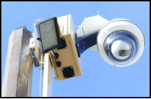
Communication for the Trapper's Point Wildlife Overpass webcam is provided by Live View Technologies in Orem, Utah. The camera has pan, zoom and tilt capabilities and operates with cell phone and satellite technology powered by solar panels. LiveView also administers many of the Wyoming WYDOT highway webcams.


News articles about the U.S.
191 Wildlife Crossing Traffic
Safety Project
Click on the links below to read media stories about the development of the U.S. 191 wildlife crossing traffic safety project. New crossings help wildlife WYDOT, Nov. 3, 2012 Wildlife passage structures working Pinedale Online, Oct. 19, 2012 Wildlife Overpass and Underpass map Wildlife Connectivity road projects continue WYDOT, Oct. 19, 2011 U.S. Department of Transportation - Federal Highway Admission 2011 Exemplorary Ecosystem Initiatives award to WYDOT June 24, 2011 (PDF) US 191 near Pinedale to get 6 wildlife crossing underpasses and 2 overpasses WYDOT, Dec. 15, 2010 Before the Overpass: How pronghorn used to have to cross through the Trappers Point bottleneck Pinedale Online, April 17, 2006, Photo sequence of highway crossing Trappers Point Wildlife Corridor Sensors WYDOT, June 10, 2005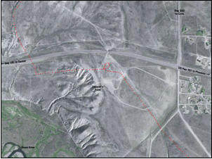
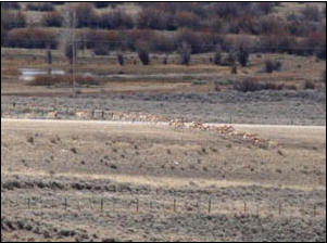
Prior to the wildlife over and underpasses
being built, migrating animals had to dart
across U.S. 191 whereever they could find a
place to cross, risking death and injury to both
animals and travelers. Pinedale Online photo
from 2006.
Overhead view from 2006 showing the
Trapper’s Point bottleneck prior to
construction of the over and underpasses. U.S.
191 goes left to right across the middle of the
page. The Cora Junction is on the right; north
goes to Green River Lakes, south is the East
Green River Road. Pinedale is about 7 miles to
the right (east). The funneling point is the
cattle underpass under the highway.
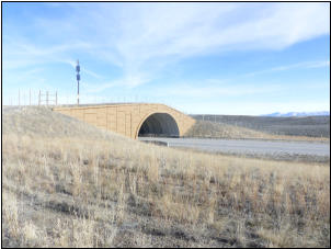
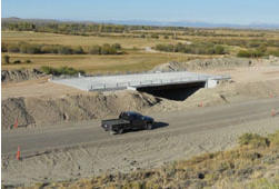
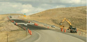
One of two wildlife overpasses built by the
Wyoming Department of Transportation in
2011 along U.S. 191 in western Wyoming.
Pinedale Online photo.
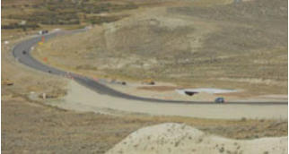
Trapper’s Point Wildlife Overpass webcam.
Photo by Pinedale Online!
Below photos show construction of wildlife
underpasses along U.S. 191 between Pinedale
and Daniel Junction in 2012. Center photo by
Wyoming Department of Transportation,
others by Pinedale Online!

© 20162020 TrappersPoint.com is part of the family of Pinedale Online websites, www.PinedaleOnline.com
Please contact Pinedale Online for questions and information about becoming a sponsor for this web page:
307-360-7689 (call or text anytime) or email support@pinedaleonline.com, PO Box 2250, Pinedale, WY 82941.

Trapper’s Point has multiple stories to tell (pronghorn, fur trapping, cattle migration)
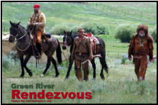
The area around Trapper’s Point is important for other activities as well. In the early 1800s, fur trappers and traders came
here and used the area just west of Trapper’s Point for six of the sixteen rendezvous held between 1824 and 1840. The
historic monument at the top of the hill to the southwest, listed as a National Historic Site, has more on that story, as does
the Musem of the Mountain Man in Pinedale, just five miles to the east. See www.mmmuseum.com for more information.
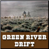
In the spring and fall, the Green River Drift takes place. Each spring and fall, ranchers with the Upper Green River Cattle
Association move livestock through Trapper’s Poiont as part of a 58-mile long cattle trail that has been continuously used
since the 1890s. In the spring, cowboys and cowgirls on horseback will move herds north to reach summer pasture on the
National Forest in the Upper Green. In the fall, colder weather will cause cattle to “drift” back south on their own, collecting
in the sorting grounds just to the south of this wildlife overpass. The Drift was listed on the National Register in November,
2013. Because it is still being used much as it has for more than 100 years, the Drift was listed as a Traditional Cultural
Property (TCP), the first ranching related TCP in the nation. See www.greenriverdrift.org for more information.
Museum open May 1 - Oct. 30, in Pinedale
Museum of the Mountain Man
June/October
www.greenriverdrift.org
March/April & Oct/Nov
www.trapperspoint.com
WILDLIFE MIGRATION
EARLY 1800s FUR TRAPPING & TRADING
HISTORIC CATTLE TRAIL